Purpose
The purpose of the South Central Resource Conservation & Development Council (South Central RC&D) is to address the needs and opportunities of the South Central RC&D area.
South Central RC&D Structure
In 1992 local citizens began discussing the Resource Conservation and Development program. Those in-volved were representatives from the conservation districts, extension offices, county governments, and non-profit organizations throughout the (4) four counties of Todd, Mellette, Jones and Tripp. In August 1992 the first application was submitted to the US Secretary of Agriculture but did not receive assistance. In June 1993 a second application for RC&D planning assistance was submitted and in February 1994 South Central RC&D was authorized by the USDA but there was no funding available for a federal coordinator. At the same time, Badlands RC&D, and Randall RC&D were looking for a new federal coordinator. Under the direction of the SD State Conservationist Dean Fisher, the three councils were able to acquire funding through a memorandum of understanding with NRCS. This would provide the flexibility for the Councils to hire its own staff. In June 2007 a federal coordinator was selected for South Central RC&D In December 1993 South Central RC&D received its designation of a 501c3 non-profit entity from the Internal Revenue Service. In April of 2011 the RC&D program nationally was eliminated from the federal budget. South Central RC&D is operating currently as a 501c3 non-profit organization.
The South Central RC&D council received its non-profit corporate status from the South Dakota Secretary of State in November 1992.
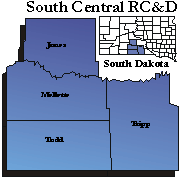
Declaration of the Area of Operation
South Central Resource Conservation and Development Council (South Central RC&D), serves the Counties of Jones, Mellette, Todd, and Tripp. Within the boundaries of Todd County lies the Rosebud Sioux Tribe Indian Reservation. Tribal lands are also located within Tripp and Mellette Counties. The total population of South Central RC&D area from the 2008 estimates is 18,854. The largest county is Todd with a popula-tion of 10,167. The smallest county is Jones with a population of 1,024. Within the area, 53.88% of the population is American Indian. There are several outlying American Indian communities in Mellette and Tripp Counties. Todd County and Rosebud Indian Reservation share the same boundaries. There has been a slow but steady decline in the population of Tripp, Jones, and Mellette Counties. Most of the population growth is shown in Todd County (≈11%). The downward population trend is especially true in smaller towns and in rural communities with the exception of American Indian areas. The persistent economic depression in the area explains the lack of jobs and business opportunities and as a result the population decline. Mellette county remains fairly constant but Todd County has shown some growth. Agriculture is the principal industry in the area and most stable jobs are provided by governments, including school dis-tricts and health care. Other employers are services, retail and tourist trade.
The economy of the area is based on agriculture with livestock and wheat crop as main productions. Live-stock production is the prime source of income with cropland used to produce livestock feed and winter wheat. There is a small number of irrigation systems operated on an individual basis. The native vegeta-tion consists of cool season grasses such as wheatgrass, needle grass and sedges intermixed with warm season grasses of the blue stems, blue grama, side oats grama and buffalo grass. With the exception of the Badlands, most of the area is relatively smooth, rolling prairies cut at intervals by small tributary drain-ages and scattered buttes. The southern portion consists of Nebraska Sand Hills and the western area is the Badlands. The major water resources in the South Central RC&D area are the Little White River and the White River. Ogallala aquifer provides some of the area water for human consumption, livestock, and irrigation. The rural water systems provide water for human and livestock consumption.
South Central RC&D area is located in the south central area of South Dakota. It has a total land base of 3,378,632 acres. The office is located in Murdo (SD) which is 50 miles southwest from the state Capital in Pierre (SD), lying to the west 136 miles is Rapid City (SD) and lying to the east 215 miles is Sioux Falls (SD). Sioux Falls and Rapid City are the largest cities in South Dakota
MISSION STATEMENT
The mission of the South Central RC&D is to provide technical assistance to facilitate working together for the viability of the area.
VISION STATEMENT
The vision of the South Central RC&D is for the area to be viable through the wise use of natural and human resources.
COUNCIL
The South Central RC&D Council consists of an appointed representative from each paid sponsor. In fiscal year 2009 there were forty-six sponsors on the council from ten different categories including counties, municipalities, conservation districts, individuals, school districts, volunteer fire departments, emergency care councils, businesses, utility company, and non-profit organizations
Program Assistant:
Jewell Bork
107 West 2nd St
P.O. Box 461
Murdo, SD 57559-0461
(605) 669-2222
(605) 669-2221 (FAX)
southcentralrcd@goldenwest.net